 '
'
Proposed Ochoco Mountains National Recreation Area
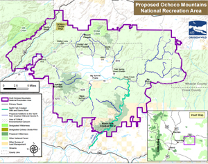 Location: Public lands within the Ochoco National Forest, including Lookout Mountain, the North Fork Crooked River watershed, the US Highway 26 scenic corridor, and adjacent Bureau of Land Management holdings along the North Fork Crooked River, all within Crook and Wheeler counties, Oregon (see map).
Size: ~312,000 acres (~284,000 acres Forest Service; ~28,000 acres Bureau of Land Management).
Managing Agencies: The National Forest System lands would continue to be managed by the Forest Service as part of Ochoco National Forest. Public lands managed by the Bureau of Land Management would continue to be managed by the BLM Prineville District.
Purposes: The proposed Ochoco Mountains National Recreation Area (OMNRA) would provide for the protection and restoration of recreational, ecological, scenic, watershed, fish and wildlife, botanical, historical, archeological, paleontological values for present and future generations.
Management Plan: The USFS and BLM would be required to jointly prepare, within 3 years, a management plan for the OMNRA.
Minerals: Federal lands would be withdrawn from all forms of location, leasing and sale under the federal mineral and geothermal laws, subject to valid existing rights.
Livestock Grazing: Livestock grazing would continue under applicable rules and regulations. Legislative language would allow for the voluntary retirement of federal grazing permits within the OMNRA from willing permit holders.
Forest Management and Fire: Forestlands would be managed to (1) protect and restore natural forest conditions, including fire and other natural disturbances and (2) protect old-growth trees. Tools would include scientifically sound ecological restoration thinning that furthers the purposes of the OMNRA. The existing collaborative forest restoration efforts would be encouraged as the OMNRA seeks to maintain a balance for the long term by protecting old-growth forests and riparian areas as well as supplying logs to the mill via restoration.
Motorized Vehicle Use: The use of motorized vehicles in the OMNRA would be limited to roads designated for such use.
Roads: The managing agencies would be required make the road system more friendly to fish, wildlife and watershed values, including meeting road density standards now required for the Ochoco National Forest. The agencies would also be directed to improve road signage to facilitate public enjoyment and understanding of open and closed roads and, where suitable, to convert unnecessary roads to trails.
Non-Motorized Recreation Use: A purpose of the OMNRA is to maintain the area as a destination for traditional, non-motorized recreation including hiking, mountain biking, horseback riding, hunting, angling, and other non-motorized activities.
Fish and Wildlife: Fish and wildlife habitat would be managed to improve conditions for all wildlife, with emphasis on redband trout, elk and non-game species. Hunting and angling would remain under the jurisdiction of the Oregon Department of Fish and Wildlife.
Invasive Species: The managing agencies would be directed to reduce, control and/or eliminate non-native invasive species from OMNRA.
Riparian and Watershed Health: Riparian zones and their associated upland areas would be managed to meet state water quality standards within ten years. Beaver would be restored throughout the OMNRA in population densities sufficient to maximize water retention and other watershed functions.
Native American Treaty Rights: The legislation would protect tribal treaty rights.
Water Rights: Existing water rights would be senior to a new junior OMNRA water right (priority date the date of establishment of the OMNRA).
Wilderness: The Lookout Mountain (9,000 acres) and North Fork Crooked River (14,800 acres) Wildernesses would be established and Bridge Creek Wilderness would be expanded (1,900 acres).
Wild and Scenic Rivers: The North Fork Crooked Wild and Scenic River would be expanded to include over 100 miles of public lands along the mainstem North Fork and key tributaries, to protect outstandingly remarkable Wild and Scenic River values, including old-growth ponderosa pine, redband trout, peck’s or longbeard mariposa lily, scenic vistas, riparian zones and recreational opportunities. Two Wild and Scenic Rivers would be established within the OMNRA outside of the North Fork Crooked River watershed.
Private Inholdings: The legislation would prohibit the use of condemnation to acquire private lands within the OMNRA, and also make clear that the OMNRA applies only to federal land. After OMNRA is enacted by Congress, private land within the OMNRA boundary would automatically become part of OMNRA if acquired by the federal government from willing sellers.
Land Exchanges: The legislation will authorize land exchanges where private land owners and federal agencies are in agreement on selected and offered lands that consolidate ownership within the OMNRA boundary.
Teaters Road: If needed, the legislation will authorize a mutually agreed solution with affected landowners to reopen Teaters Road to reestablish public access into the OMNRA.
Draft June 8, 2015
For More Information please contact:
Jamie Dawson, Oregon Wild
541-382-2616