With summer in full swing, kids out of school, and (somewhat) sunny weather, today we are sharing a perfect hike for a fun family outing. This hike at Lost Lake is the fourth featured hike in our summer series to promote outdoor adventures and our new book, Oregon's Ancient Forests: A Hiking Guide.
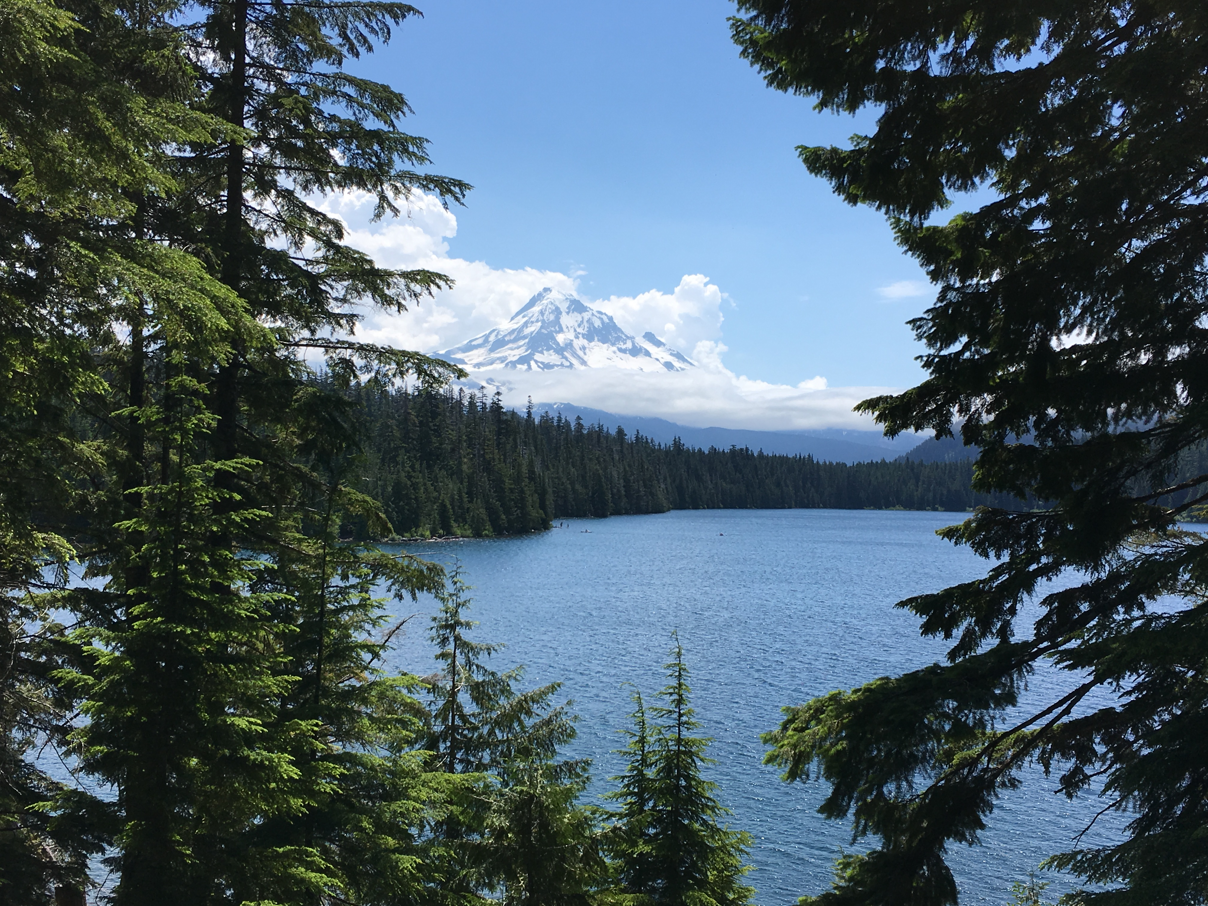
This scenic loop around Lost Lake is great for families and beginner hikers. The trail is flat and in just 3 miles you can enjoy great views of Mount Hood, see beautiful wildflowers, bask in old-growth forests, look for birds, and even splash in the lake! Bring your camera to document the incredible sights (and remember to submit your photos to our 15th annual outdoor photo contest!). And be sure to grab an ice cream treat at the general store for a refreshing post-hike snack.
You can also spend the night at Lost Lake campground to enjoy the tranquil waters (only non motorized boating is allowed) and pure mountain air a little longer. For more information about camping, cabins, and canoe rental at Lost Lake, visit the Lost Lake Resort website.
-----------------------------------------
Lost Lake - The Hike:
Distance: 3.2 mile loop
Difficulty: Easy
Elevation Gain: Minimal
First, Some Background:
Lost Lake is currently managed by the Mount Hood National Forest. Oregon Wild and other conservation groups are currently working to gain Wilderness protection for Lost Lake as part of the Lewis and Clark Mount Hood Wilderness Proposal. Wilderness protection would forever safeguard the land from logging, mining, and other development while preserving the public’s right to enjoy backcountry recreation.
While driving to Lost Lake you will pass through miles of clear-cut private land, managed exclusively for timber production on the fertile north slopes of Mount Hood. After entering the national forest though, you’ll find huge old trees draped in lichen - a stark contrast to the clearcuts. On this hike you can also take note of the forested ridge to the west of Lost Lake. This ridge divides the Hood River drainage from the Bull Run watershed just to the west—the source of Portland’s drinking water.
How to Get There:
From Portland, go east on Interstate 84 and take exit 62 for US Highway 30 east. Turn right on Highway 30 (Cascade Ave) and then turn right on Mount Adams Avenue. Mount Adams Avenue turns slightly right and becomes Wine Country Avenue and then becomes Country Club Road. Continue for about 3 miles and turn left onto Barrett Drive. In 1.2 miles, turn right onto Tucker Road (Oregon Route 281). Stay right toward Odell, Dee, and Parkdale to stay on OR 281 2 miles later. Drive along the Hood River for 6 miles and then turn right for Dee and Lost Lake. Cross the East Fork Hood River, stay left on Lost Lake Road, and follow curves and signs to stay on Lost Lake Road. 8 miles after turning onto Lost Lake Road, turn right at a sign for Lost Lake Resort 6 miles. You’ll reach the entrance station 13.8 miles after turning off OR 281. Here you must pay an entrance fee. Then proceed ahead and stay to the right toward the general store and boat rental area. Continue left to cross the small bridge at Lake Branch Creek and park in the large parking loop at the end of the road. Note that there is a $9 day-use fee required to park (the Northwest Forest Pass does not apply).
Hike Description:
From the end of the parking loop, start down the Lost Lake Shoreline Trail to circle the lake in a counter-clockwise direction. During the first mile the trail crosses several boardwalks and also offers spots to step down to the lakeshore to find great views of Mount Hood. Be sure to soak in these views of Mount Hood before it disappears behind the butte on the lake’s southwestern shore. In 1.5 miles, the trail climbs onto the north side of a lakeside butte. Cross a rocky gully (with flowing water during spring’s snowmelt) and descend right to the lake’s shore, skirting a rocky slope. At 1.7 miles, climb again into the edge of the forest and pass a few huge tree specimens: noble and silver firs and a redcedar over four feet in diameter. As you round the south end of the lake, you’ll reach another boardwalk in another wet, flat area. At about the 2-mile point, you will pass the junction with the Huckleberry Mountain Trail. Stay on the shoreline trail at a sign for the old-growth trail and day-use area. Over the next mile you’ll pass campsites as the trail alternates between boardwalk and natural surface. Stay on the unpaved path along the shore as you pass picnic sites to reach the boat rental area and a sasquatch statue. Continue to the left to cross the lake’s outlet steam on a bridge, then pass another picnic area to finish the loop back to the parking area.
Along this loop you’ll find Douglas-firs, western redcedars, western hemlock and noble firs. The canopy’s lower layers will include vine maple, huckleberry, and bunchberry. In the boggy areas, look for water-loving vegetation, like skunk cabbage, salmonberry, red-twig dogwood, mountain ash, and alder. And closer to the lake you will also find salmonberry, devil’s club, thimbleberry, goatsbeard, and elderberry.
-----------------------------------------
Got the hiking bug? Be sure to check out our new book, Oregon’s Ancient Forests: A Hiking Guide by Chandra LeGue, to discover 91 awe-inspiring hikes like this one and learn more about ancient forests. Get your copy online, in select bookstores, or at one of our book events throughout the summer. These events are happening in locations around the state and we’d love for you to join! Click here for more info on events, or visit our Facebook page.
Follow along for book updates on Facebook at Oregon’s Ancient Forests and Instagram @oregon_ancient_forests. And in return, we’d love to follow along on your ancient forest adventures! Tag your forest photos with #OregonOldGrowth and #ORAncientForests.
For more hikes and outdoor adventures, check out our suggested outings page.