
Today, Oregon Wild announced the publication of new trail images on Google Maps, in partnership with the technology company. With the help of some other staff and volunteers, I "collected" these images earlier this summer - possibly drawing a few interested double-takes from anyone who saw us out hiking with a big spherical camera system on a funny looking backpack…
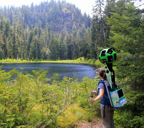
The contraption on my back might have looked familiar to anyone who has seen a Google Street View car in their neighborhood. The bright green orb hovering 2 feet above my head was, basically the "trail view" version of a Street View camera. Known as a Trekker, the system collects panoramic images of trails and other landscapes only accessible by foot through its 15 lenses – taking a photo every few seconds as you walk along, then stitching them together with fancy technology.
Wearing the device was an interesting experience. Weighing in at over 40 pounds, with the large camera up top, the Trekker was a bit more cumbersome than my usual day pack. I felt a bit wobbly on some of the “trails” I used it on, as few were well-maintained. Waiting for the system to get up and running before I could start hiking was an exercise in patience too – at least when I’m waiting for my hiking buddies to tie their shoes I can talk to them without feeling crazy.
Fortunately, I didn’t encounter many people on the trails I hiked with the Trekker, so there weren’t too many funny looks. And that was kind of the point: Most of the places I took it to were hard to find or hard to get to, but are important pieces of the ecological patchwork that make up our backyard forests in western Oregon. Several of them are also threatened. For example, some of the places I documented with the Trekker are tied up in the BLM’s plan revision process, which could increase logging and decrease streamside protections. For example, the featured Fall Creek area running through Salem District Bureau of Land Management (BLM) lands borders private timberlands that are routinely clearcut. The images captured by the Google Trekker showcase a hike through a beautiful forest, but it is an island of old growth in a sea of industrial tree plantations. Many local residents and people who recreate in the area have been working to ensure that this area near the Alsea Falls Recreation Area gains some protections under any new BLM plan, but such are not guaranteed.
Our hope is that through the Google Street View Trekker loan program we can reach people in a unique way - with spectacular images of remote places they may never get a chance to visit. We all know that people are more effective advocates for a place when they can see and experience it for themselves. Shy of their own explorations, the Trekker images might be the next best way of motivating people to care about and advocate for these special places in western Oregon.
Explore the Google Trekker images we helped collect:
- Fall Creek Old-growth Area
- Crabtree Valley
- Green Springs Mountain
- Little Applegate: Sterling Mine Ditch Trail
- Wellington Wildlands
- Grandmothers Grove
And some of the media coverage of our time with the Trekker:
- On OPB radio
- In the Salem Statesman Journal