In a state covered in nearly 30 million acres of forested lands, it can be difficult to get a sense of the scale and extent of logging across Oregon.
Sure, you can pass miles of clearcuts and young plantations as you drive to the coast, but most forest lands aren’t accessible from major highways. A view from above, looking down from an airplane window for example, can give you a better sense, but this is still just a snapshot in time. This is one reason Oregon Wild volunteer Ricardo Morin spent hundreds of hours over the past year developing a “Logging in Oregon” web tool for analyzing the extent of logging on both public and private lands in Oregon, both historically and recently. (Check out some of his other cool mapping work for Oregon Wild here.)
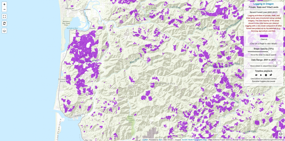
With the tool, you can explore more recent “forest loss” (aka logging) on private, state and tribal lands from 2001-2017. For example, in Tillamook County (especially near the community of Rockaway Beach), it’s easy to see the huge impact of clearcuts on coastal watersheds in recent years. This analysis is complimentary to other time-lapse videos showing the destruction of whole watersheds in real color.
For federal public land, detailed logging data is available by clicking on “Federal public lands” and then clicking on an agency sign logo on the map. You can then use the slider tool to adjust the date range – or do a time-lapse. Most logging begins in earnest in the 1950s and picks up speed and force through the 1980s. If you click on an individual forest stand, it will display the name of the project, the method of logging*, and the date it was logged. You can also note, for example, the shift from clearcut logging to thinning on public lands in many places.
*While some National Forests have data available for “thinning” vs clearcuts, not all do.
When “zoomed in” to the data from one National Forest or BLM District, you can’t see the other areas, so zoom back out by clicking “Logging in Oregon” (in the upper right corner) to see the big picture again before exploring another area.
Oregon Wild intends to use this mapping tool to help advocate for forest conservation and demonstrate that while there have been temporal pulses of increased logging intensity over the years, logging is always very active on both public and private forests in Oregon. In fact, if anything, the analysis on this site underrepresents the true extent of logging taking place.
The tool is also a great visualization of the few Wilderness and roadless wild lands remaining in the state - while it does not highlight these areas, they are clearly visible by their noticeable lack of logging units. These last bastions of wild landscapes are far too rare in Oregon, a reason Oregon Wild is working to protect what is left.
We can also use the tool to push back on misinformation spouted by timber interests.
- Many say that logging on public land was “shut-down” by the spotted owl and Northwest Forest Plan, first implemented in 1994, but the data shows that logging continued apace throughout the Northwest Forest Plan region after the plan was adopted.
- Logging advocates also say we need the increase the “pace and scale” of logging to reduce fire hazard in the dry forests of eastern and southwest Oregon, but the data show that thinning has already occurred across vast portions of these forests.
A few notable examples to explore:
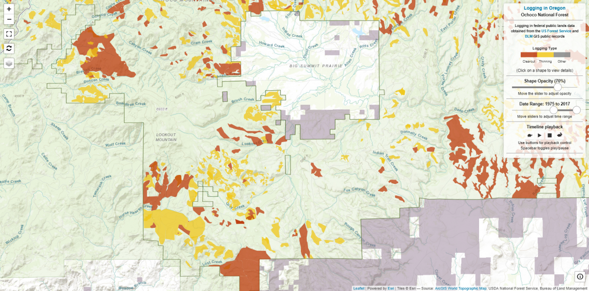
- Ochoco National Forest, Lookout Mountain area: The area shown below includes the Lookout Mountain roadless area, just southwest of the large, privately owned and ranched Big Summit Prairie area (look for the blank spots on the map – where no logging has occurred). The Ochoco National Forest in this area has seen significant “thinning” in recent years. Such efforts can help counter the effects of decades of fire suppression in dry forest types, but can also be focused less on restoration and more on producing timber volume.
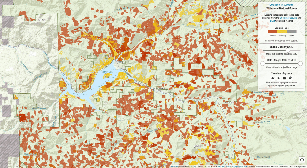
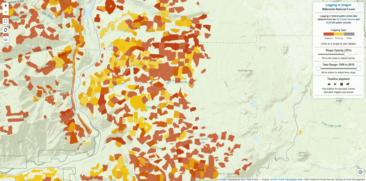
- Willamette National Forest, Upper McKenzie River Watershed: If you follow the McKenzie River upstream from Eugene-Springfield to where it and Hwy 126 turns to head north, you’ll find the area included in the proposed “Flat Country” timber sale, shown below, currently in planning by the Willamette National Forest. The area encompasses the Boulder Creek and Scott Creek drainages, and is heavily colored on the map due to past logging. The Mount Washington Wilderness is seen clearly – no logging has occurred in this area to the east of “Flat Country.” Past logging here, and the very few remaining unlogged forests found between past clearcuts isn’t holding the Forest Service back from proposing additional heavy logging, including in natural, never-before-logged forests.
Data caveats: This mapping analysis is the compilation of the best available data sources for current and historic logging in Oregon. Some National Forests have better records for where logging has occurred than others, so there are some gaps where not all of the logging is displayed. Note that in some places you can see all logging vs clear cuts vs thinning. Older logging activities are less accurate and available compared to more recent years. Mapping thousands of stands that have been logged over the years not surprisingly has a margin of error. We estimate a +/- 5% margin of error for areas we’ve mapped and identified.