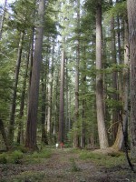
 Old-growth forests are one of our state's treasures, providing homes for an incredible array of plant and animal species, some endangered and some not, and giving humans a place to fish, hike, hunt, camp and enjoy nature.
Although logging has destroyed most of these forests, we're fortunate that some of our old-growth and mature forests are still relatively intact, and its important to keep them this way. Oregon Wild has inventoried the mature and old-growth forests in some of Oregon's oldest, most intact landscapes.
There is no exact definition for what constitutes a mature or old-growth forest. For the purpose of mapping the general location of these forests, mature forests are defined 80-120 years of age, and old-growth as 120 years and older. This generalized range provides an idea of where mature and old-growth forests exist in Oregon. Oregon Wild believes these maps to be the most accurate depiction of mature and old-growth trees for these areas, but its important to note that the data is not perfect.
Mount Hood National Forest Interactive Map (moderate+ accuracy)
Siuslaw National Forest interactive Map (moderate- accuracy)
Willamette National Forest interactive map (good accuracy)
Blue = Mature forests 80-120 years of age
Green = Old-Growth Forests 120+ years of age
Forest inventories were created using a variety of source data including USFS data.